The Federal Aviation Administration has released its first “Roadmap” that explains what will be needed to safety integrate the use of unmanned aircraft systems (UAS) into the national airspace of the U.S. The five-year plan discusses three phases that include the “accommodation” of existing UAS on a limited basis, the “integration” of future UAS — including establishing performance standards for the construction and operation of UAS — and “evolution” to assure rules and regulations can be adaptable to the rapidly changing use and development of UAS potential in the states.
“Government and industry face significant challenges as unmanned aircraft move into the aviation mainstream,” U.S. Transportation Secretary Anthony Foxx said in a release. “This Roadmap is an important step forward that will help stakeholders understand the operational goals and safety issues we need to consider when planning for the future of our airspace.”
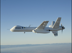
Various UAS have been operating within the U.S. airspace on a limited basis for many years. Large aircraft such as General Atomic Predator have been used for border patrol operations, taking off and landing at general aviation airports alongside other aircraft. NASA has also been using its own version of the Predator known as the Ikhana (pictured above) to help monitor forest fires as well as other research projects. And of course there are thousands of smaller UAS that are being used by farmers, law enforcement, filmmakers, photographers and people who are simply fascinated by the technology.
Today the use of larger unmanned aircraft, and smaller UAS that fly beyond the line of sight of the operator are only allowed on a case-by-case basis. Smaller UAS that are flown only short distances and at low altitudes within sight of the operators, are largely unregulated and operated in a similar manner as remote control aircraft have been flown by hobbyists for decades. But there have been many challenges by some who see a grey area between the two examples. The future rules outlined in the road map will provide standardized regulations that would cover all UAS that plan to operate in the national airspace, providing long awaited opportunities for many, though tighter restrictions for others.
The FAA Roadmap (PDF) talks about a future where “routine UAS operations will not require the creation of new special use airspace, or modification of existing special use airspace,” implying that with the new rules that are being developed, the unmanned aircraft will be treated the same as manned aircraft. To get to this point, the plan outlines the certification of UAS pilots (acknowledging that it will be different than the requirements for manned aircraft), as well as airworthiness rules for UAS that the agency says will bring them up to similar standards used for manned aircraft. The road map also mentions the unique requirements for UAS such as robust and reliable data link systems that will be needed to ensure safe flight.
For the next several years, the FAA expects to allow limited, special-use of UAS on a case-by-case basis as is done now. This is part of the “accommodation” of UAS in the current airspace. The next phase would be develop “tailored type certificates” for UAS that would have limitations, and would still limit the use of the aircraft, but provide a more integrated system, leading to the final phase. In the end there would be a set of rules and regulations that would certify both pilots and aircraft in a similar manner that is done today with manned aircraft, and allow the widespread integration of UAS into the national airspace.
Key concerns for the FAA continue to be the ability to “sense and avoid,” along with the “control and communication” of the aircraft. The FAA will be designating six testing areas where new and existing technologies can be tested to establish the performance requirements needed for the UAS to operate with other aircraft, and maintain communication with the operator/pilot. The FAA says the test sites will also help “inform the dialogue” regarding privacy and civil liberty issues regarding UAS, though the agency acknowledges this is not part of its mission.
The FAA road map outlines a future for UAS that many have been anticipating for several years. For those waiting to use larger UAS and smaller examples that can fly beyond the line of sight, it’s a long awaited first step in allowing their widespread use within the United States. And for enthusiasts and others who have been using the smaller unmanned aircraft, new rules and regulations aimed at integrating them into the airspace could mean their future use won’t be quite as open or easy as it is now. (Wired.com)
In simple English Please!
This is the opinion of Unmanned Vehicle University. There are no FAA regulations yet
The FAA CONOPS for UAV operations will include two categories:
Category 1 Small UAVs less than 55 pounds Daytime Only VFR, line of sight Permit Required Pass multiple choice exam Demonstrate flight proficiency, medical certificate
Category 2 Everything Else Treat UAS like a manned aircraft, Requires transponder and ADS-B out, Each PIC controls one UAV, Autonomous operations not permitted, No new classes or types of airspace, Air traffic separation minimums in controlled airspace apply to UAS, ATC responsible for separation for manned and unmanned, PIC complies with ATC instructions, use standard phraseology.
Before you start operating UAVs in US National Airspace (NAS) you must be aware of the Federal Aviation Regulations (FARs). The primary reference for UAS operations is National Policy Document N8900.227 dated July 13, 2013. N8900.227 also has pilot and observer qualifications and training requirements. Always check the FAA website to get clarification on any misunderstandings you may have. You can also call the Manager of the FAA’s UAS Integration Office at 202-385-4835.
According to the FAA UAS Fact Sheet posted on the FAA website there are two ways you can legally operate a UAV in the NAS. The first is to obtain a Certificate of Authorization (COA) and the second is to obtain an experimental certificate. You also need to distinguish between public and civil operations. Public operations basically refer to City, State or Federally owned UAVs and civil is everything else. It used to be that only government agencies and not for profit universities could obtain a COA. Section 9 of N8900.227 now says that a COA can be obtained for civil and commercial operations.
The rules for applying for an experimental certificate are contained in CFR 91.125 and operating limits are contained in FAR 91.319. Note that 91.319 says you cannot carry persons or property for compensation or hire. According to 91.319 you can charge for your services as long as you don’t carry persons or property. If you carry a payload, that is not persons or property and you could legally charge for your services.
Everyone is waiting for the key date of Sept 2015 for passage of regulations for UAVs as the milestone for when they can charge for services. As of August 2013, this is not a correct assumption. In that month the FAA approved a restricted type certificate for the AeroVironment PUMA and Insitu Scan Eagle drones. They also approved Insitu to charge their first customer, ConocoPhillips, for aerial survey operations in Alaska. You can read all about restricted type certification in FAA Order 8110.56A. You will need to fill out FAA Form 8110-12 to apply for the type certificate. Once you have a type certificate you can operate in accordance with CFR 21.25. Note Part 2 which opens the door for you to start a business and conduct the special operations that are listed.
We recommend that you take a look at one other regulation called FAA National Policy Document 8130.34C, Airworthiness Certification of Unmanned Aircraft Systems and Optionally Piloted Aircraft. In order to obtain a restricted type rating you must obtain a special airworthiness certificate. You can apply for this by filling out form 8130-7. Finally you will also need to obtain a Registration Certificate and Aircraft Flight manual. Most UAVs don’t have flight manuals so if you decide to become a manufacturer and want certification you should get an operations manual together. By the way, we did not make this up, everything in this Chapter came directly from the FAA.
In summary, to operate a drone legally in the NAS, you will need to get a special airworthiness certificate, restricted type certificate, registration certificate, a commercial COA and a flight manual to be legal to fly in the NAS. Don’t forget to scan N8900.227 to make sure you are qualified as a pilot. Or you can save yourself all the hassle and buy a Scan Eagle or PUMA and apply for a commercial COA.
300 Commercial Applications for UAVs
“Government and industry face significant challenges as unmanned aircraft move into the aviation mainstream,” U.S. Transportation Secretary Anthony Foxx said in a release. “This Roadmap is an important step forward that will help stakeholders understand the operational goals and safety issues we need to consider when planning for the future of our airspace.”
Various UAS have been operating within the U.S. airspace on a limited basis for many years. Large aircraft such as General Atomic Predator have been used for border patrol operations, taking off and landing at general aviation airports alongside other aircraft. NASA has also been using its own version of the Predator known as the Ikhana (pictured above) to help monitor forest fires as well as other research projects. And of course there are thousands of smaller UAS that are being used by farmers, law enforcement, filmmakers, photographers and people who are simply fascinated by the technology.
Today the use of larger unmanned aircraft, and smaller UAS that fly beyond the line of sight of the operator are only allowed on a case-by-case basis. Smaller UAS that are flown only short distances and at low altitudes within sight of the operators, are largely unregulated and operated in a similar manner as remote control aircraft have been flown by hobbyists for decades. But there have been many challenges by some who see a grey area between the two examples. The future rules outlined in the road map will provide standardized regulations that would cover all UAS that plan to operate in the national airspace, providing long awaited opportunities for many, though tighter restrictions for others.
The FAA Roadmap (PDF) talks about a future where “routine UAS operations will not require the creation of new special use airspace, or modification of existing special use airspace,” implying that with the new rules that are being developed, the unmanned aircraft will be treated the same as manned aircraft. To get to this point, the plan outlines the certification of UAS pilots (acknowledging that it will be different than the requirements for manned aircraft), as well as airworthiness rules for UAS that the agency says will bring them up to similar standards used for manned aircraft. The road map also mentions the unique requirements for UAS such as robust and reliable data link systems that will be needed to ensure safe flight.
For the next several years, the FAA expects to allow limited, special-use of UAS on a case-by-case basis as is done now. This is part of the “accommodation” of UAS in the current airspace. The next phase would be develop “tailored type certificates” for UAS that would have limitations, and would still limit the use of the aircraft, but provide a more integrated system, leading to the final phase. In the end there would be a set of rules and regulations that would certify both pilots and aircraft in a similar manner that is done today with manned aircraft, and allow the widespread integration of UAS into the national airspace.
Key concerns for the FAA continue to be the ability to “sense and avoid,” along with the “control and communication” of the aircraft. The FAA will be designating six testing areas where new and existing technologies can be tested to establish the performance requirements needed for the UAS to operate with other aircraft, and maintain communication with the operator/pilot. The FAA says the test sites will also help “inform the dialogue” regarding privacy and civil liberty issues regarding UAS, though the agency acknowledges this is not part of its mission.
The FAA road map outlines a future for UAS that many have been anticipating for several years. For those waiting to use larger UAS and smaller examples that can fly beyond the line of sight, it’s a long awaited first step in allowing their widespread use within the United States. And for enthusiasts and others who have been using the smaller unmanned aircraft, new rules and regulations aimed at integrating them into the airspace could mean their future use won’t be quite as open or easy as it is now. (Wired.com)
In simple English Please!
This is the opinion of Unmanned Vehicle University. There are no FAA regulations yet
The FAA CONOPS for UAV operations will include two categories:
Category 1 Small UAVs less than 55 pounds Daytime Only VFR, line of sight Permit Required Pass multiple choice exam Demonstrate flight proficiency, medical certificate
Category 2 Everything Else Treat UAS like a manned aircraft, Requires transponder and ADS-B out, Each PIC controls one UAV, Autonomous operations not permitted, No new classes or types of airspace, Air traffic separation minimums in controlled airspace apply to UAS, ATC responsible for separation for manned and unmanned, PIC complies with ATC instructions, use standard phraseology.
Before you start operating UAVs in US National Airspace (NAS) you must be aware of the Federal Aviation Regulations (FARs). The primary reference for UAS operations is National Policy Document N8900.227 dated July 13, 2013. N8900.227 also has pilot and observer qualifications and training requirements. Always check the FAA website to get clarification on any misunderstandings you may have. You can also call the Manager of the FAA’s UAS Integration Office at 202-385-4835.
According to the FAA UAS Fact Sheet posted on the FAA website there are two ways you can legally operate a UAV in the NAS. The first is to obtain a Certificate of Authorization (COA) and the second is to obtain an experimental certificate. You also need to distinguish between public and civil operations. Public operations basically refer to City, State or Federally owned UAVs and civil is everything else. It used to be that only government agencies and not for profit universities could obtain a COA. Section 9 of N8900.227 now says that a COA can be obtained for civil and commercial operations.
The rules for applying for an experimental certificate are contained in CFR 91.125 and operating limits are contained in FAR 91.319. Note that 91.319 says you cannot carry persons or property for compensation or hire. According to 91.319 you can charge for your services as long as you don’t carry persons or property. If you carry a payload, that is not persons or property and you could legally charge for your services.
Everyone is waiting for the key date of Sept 2015 for passage of regulations for UAVs as the milestone for when they can charge for services. As of August 2013, this is not a correct assumption. In that month the FAA approved a restricted type certificate for the AeroVironment PUMA and Insitu Scan Eagle drones. They also approved Insitu to charge their first customer, ConocoPhillips, for aerial survey operations in Alaska. You can read all about restricted type certification in FAA Order 8110.56A. You will need to fill out FAA Form 8110-12 to apply for the type certificate. Once you have a type certificate you can operate in accordance with CFR 21.25. Note Part 2 which opens the door for you to start a business and conduct the special operations that are listed.
We recommend that you take a look at one other regulation called FAA National Policy Document 8130.34C, Airworthiness Certification of Unmanned Aircraft Systems and Optionally Piloted Aircraft. In order to obtain a restricted type rating you must obtain a special airworthiness certificate. You can apply for this by filling out form 8130-7. Finally you will also need to obtain a Registration Certificate and Aircraft Flight manual. Most UAVs don’t have flight manuals so if you decide to become a manufacturer and want certification you should get an operations manual together. By the way, we did not make this up, everything in this Chapter came directly from the FAA.
In summary, to operate a drone legally in the NAS, you will need to get a special airworthiness certificate, restricted type certificate, registration certificate, a commercial COA and a flight manual to be legal to fly in the NAS. Don’t forget to scan N8900.227 to make sure you are qualified as a pilot. Or you can save yourself all the hassle and buy a Scan Eagle or PUMA and apply for a commercial COA.
300 Commercial Applications for UAVs

For those interested in a career in unmanned aircraft systems there will soon be tens of thousands of jobs available. In the Canada, the United Kingdom, Australia and many other countries it is possible to obtain a license or permit to operate a UAV commercially. In the USA, however this has not been possible until now. The FAA recently passed a law to allow first responders including law enforcement agencies to fly a UAV below 25 pounds below 400 feet. This is a huge step toward commercial operations. There are over 18,000 police departments and when sheriff departments are added the number approaches 100,000. This is a huge market for commercial UAV producers to sell their UAVs to.
UVU prepares students to become program managers and systems engineers in companies that develop UAVs for civil and commercial applications. With a Doctorate or Masters Degree in Unmanned Systems Engineering, you will be responsible for managing new UAV development programs. The FAA is preparing a new rule called Special Federal Aviation Regulation 107 which will open the doors to commercial operations for small UAVs weighing less than 55 pounds to fly below 400 feet. This law could pass within the next year. Companies will develop UAVs customized for specific applications. As an unmanned systems engineer you will be leading these developments with the specialized knowledge you gain from the world experts on our faculty. Graduates can expect to earn between $90,000 and $130,000 per year. These figures come from Salary.com and are for systems engineers and program managers. You will most likely be involved in one of the applications listed below.
SHARK WATCH IN AUSTRALIA PRECISION FARMING 80% of UAV application will be for farming. Infrared sensors can discover fertile and non fertile areas on a farm. This will allow farmers to apply fertilizer only where needed instead on on the entire farm. Hyperspectral sensors have shrunk to 1-2 pounds and can be employed on a UAV to discover disease in crops.
John Deere is building autonomous tractors and researchers at Virginia Tech are using UAVs to collect samples to track microbes that cause disease in plants. It may be possible to use this information to spray fungicide before the microbes arrive. Japan is using UAVs for crop dusting of rice fields and using precision ground robots to harvest $5 strawberries.
CUSTOMS & BORDER PATROL US Customs currently has 9 Predator UAVs that are equipped with sophisticated night vision and infrared surveillance equipment, these drones are capable of cruising continuously for 30 hours and can identify vehicles and people from an altitude of 50,000 feet while their operators control them from a base thousands of miles away.
Missions include border patrols, surveys and control, counter narcotics and illegal alien surveillance; counter- terrorist nuclear, biological, and chemical (NBC) detection of weapons of mass destruction (WMD)
FIREFIGHTING Using a UAV for firefighting does not just save money, it eliminates the risk topilots. UAVs can go to any scene, anywhere, launch, and be able to share that imagery immediately with the battalion chief on the ground, an Incident Commander on the ground or an Emergency Operations Center anywhere. The UAV can be programmed with GPS coordinates to fly a pattern automatically.
LAW ENFORCEMENT There are already ten police agencies using UAVs in law enforcement. A commercial market exists for supplying and training customers that will come from the over 18,000 law enforcement agencies in the USA.
Federal Emergency Management Agency (disaster area surveys and assessment, facilitate relief operations, communications relay)
Coast Guard (surveillance for counter narcotics, illegal aliens, illegal fishing, national security threats; search and rescue operations)
Department of Agriculture (pesticide & fertilizer spraying, insect sampling (bug catching), farm management)
National Aeronautics and Space Administration (high altitude atmospheric sampling, such as for ozone and pollution, astronomical sensing)
Forest Service (area surveillance of forest to determine plant growth and provide fire control, counter narcotics surveillance, mapping, firefighting with water or chemicals)
Weather Service (storm observation, tornado chaser)
Fish and Wildlife (river and estuary surveys for illegal hazardous waste dumps, wildlife tracking and accounting in remote areas, mapping, counter poaching, fishing law enforcement)
Department of Energy (monitoring nuclear facilities, reconnaissance for hazardous waste cleanup, atmospheric and climatic research)
Bureau of Land Management (archeological surveys and monitoring, hazardous waste dump surveys and monitoring)
State and Local Law Enforcement ( Riot control, area surveillance, highway patrol, counter narcotics surveillance, search and rescue)
State Department (area security surveillance)
Drug Enforcement Agency (counter narcotics surveillance)
Environmental Protection Agency (air sampling, hazardous waste dump surveys and monitoring)
Department of Transportation (traffic and highway surveys and monitoring, crash mitigation, mapping)
Engineers [civil missions] (monitoring recreational areas, surveying for dams, levees, and other construction projects, disaster control)
Communication Relay (equivalent to low-altitude satellites or cell towers)
Security (surveillance, counter-terrorism, detection of NBC & WMD)
Media (overhead cameras for news and special events)
Real Estate (pictures for selling property, surveying)
Surveying (city and suburban planning)
Farming and Ranching (check on cattle, fence lines, and work crews, spraying crops with pesticide and fertilizer, monitoring crops, soil, moisture, and pest conditions, and insect sampling)
Maritime (monitoring and reconnaissance of fishing areas, shipping hazards and disasters, and search and rescue)
Film Industry (aerial photography and special effects)
Archaeology (aerial observation of sites and digs)
Oil and Mineral Industry (gas and oil pipeline monitoring in desolate areas, search for mineral and fossil fuel deposits)
Railroads (aerial monitoring of rail lines and trains for operations and accidents)
 RSS Feed